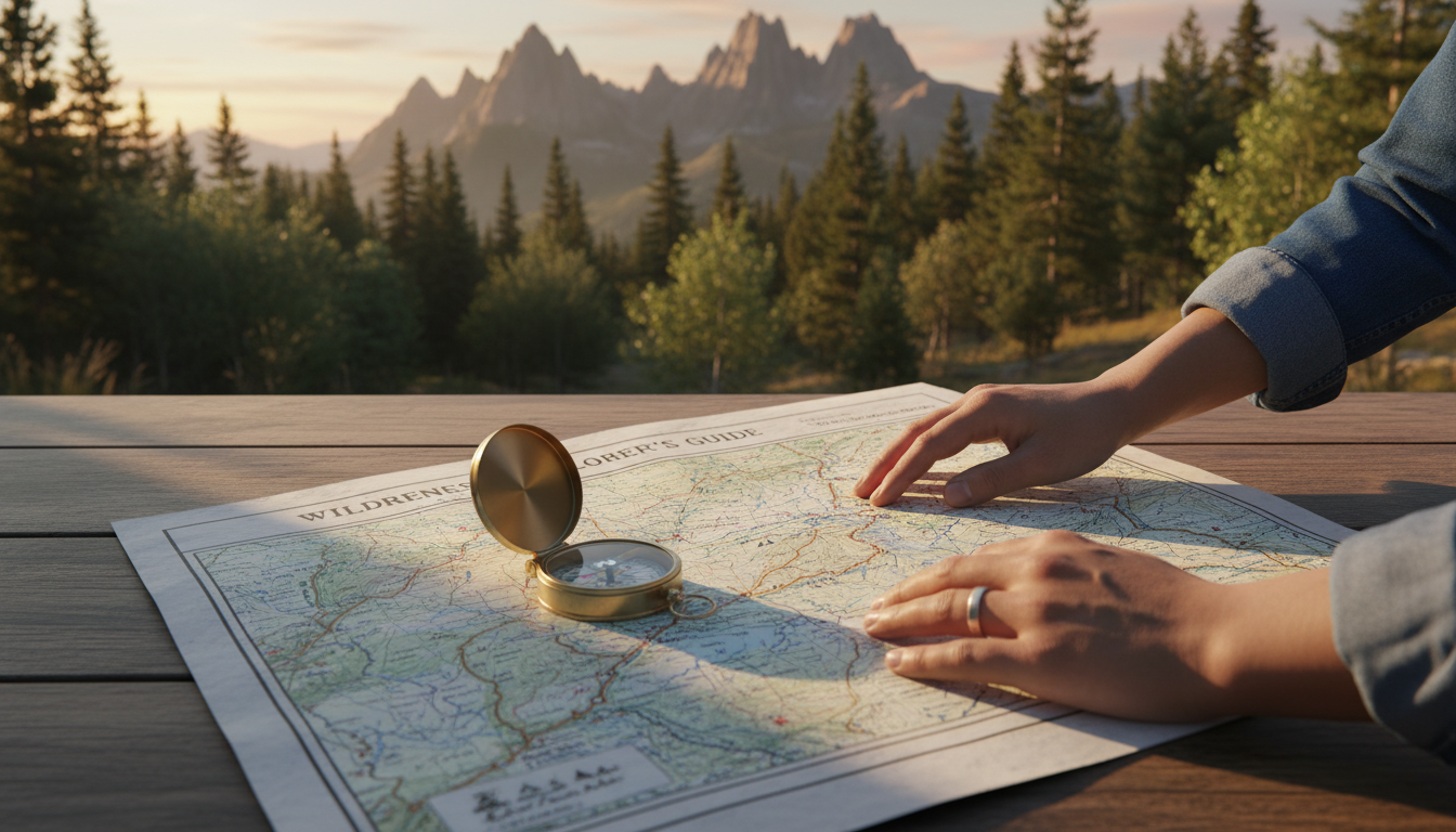
Learning to use a map and compass is timeless. Even with GPS and smartphones, these tools are essential. A compass doesn’t need batteries and works with any map. It’s perfect for places where tech fails.
A topographic map shows you where things are and how to get there. It highlights the land’s shape and natural features like forests and streams. You can also find buildings and bridges on these maps. Using a map with a compass lets you explore with confidence.
Navigation basics might seem hard at first. Many think they can’t read maps or use compasses. But, anyone can learn these skills. You don’t need special talents or years of training.
This guide will teach you everything you need to know. You’ll learn about compass parts and how they work. You’ll discover how to read topographic maps and understand magnetic declination. Most importantly, you’ll gain confidence to navigate in the wilderness.
Hikers, campers, hunters, and fishers all need strong navigation skills. Outdoor explorers of all types rely on these techniques. Knowing how to use a map and compass keeps you safe. It lets you explore less-traveled areas with confidence.
This journey starts here. Step by step, you’ll master map and compass navigation. Your outdoor adventures are about to get more exciting.
Table of Contents
Understanding Your Compass and Its Essential Features
Before you venture into the wilderness, it’s vital to know your compass well. A good compass is your ally in mastering compass bearing techniques. It’s like a puzzle, with each piece essential for navigation. Knowing what each part does makes it easier to find your way.
The Magnetic Needle and Cardinal Points
The heart of every compass is a magnetized needle that always tells the truth. The red end always points toward magnetic north, no matter the direction. This red needle is your constant guide. The white or black end points toward magnetic south. You can’t rely on your eyes or instinct when navigating. The needle does the work for you.
Compasses use four cardinal points to show direction:
- North (N) — marked as 0 or 360 degrees
- East (E) — marked as 90 degrees
- South (S) — marked as 180 degrees
- West (W) — marked as 270 degrees
The 360-degree marking system helps you be precise when using compass bearing techniques in the field.
Baseplate Components and Direction of Travel Arrow
Your compass sits on a clear plastic baseplate that lets you see through to your map below. This transparent design is key for map reading. The direction of travel arrow is the large arrow pointing away from the compass housing. This arrow shows which way your body should move.
Key baseplate features include:
- Clear plastic base for viewing maps beneath
- Ruler edges marked for 1:25,000 and 1:50,000 map scales
- Index line extending from the direction of travel arrow
- Romer scales for quick distance measuring
- Orienting lines running parallel across the baseplate
These lines and markings work together to support your compass bearing techniques and keep you on track.
The Azimuth Ring and Orienting Arrow
The azimuth ring is the rotating bezel that spins around the compass dial. It displays all 360 degrees marked in two-degree increments. You can turn this ring to set your desired bearing. Inside sits the orienting arrow, a fixed outline arrow that stays aligned to north. These two parts work as a team when mastering compass bearing techniques.
| Component | Purpose | How It Helps |
|---|---|---|
| Magnetic Needle | Points toward magnetic north | Provides constant directional reference |
| Azimuth Ring | Rotates to set bearings | Allows precise degree selection |
| Orienting Arrow | Fixed alignment to north | Helps match map to landscape |
| Baseplate | Transparent plastic foundation | Enables map viewing and measurement |
| Direction of Travel Arrow | Shows forward direction | Guides your walking path |
Understanding these features gives you the confidence to use compass bearing techniques correctly. Each part serves a specific purpose in your navigation success.
Map Scales and Measuring Distance on Topographic Maps
Learning about map scales is key to using topographic maps. A map scale shows how map distances relate to real-world distances. This skill helps you plan hikes and estimate travel time.
Map scales are ratios. For example, a USGS map is 1:24,000. This means 1 inch on the map is 2,000 feet in real life. Another scale, 1:63,360, means 1 inch equals 1 mile. Knowing your scale is vital for navigation.
- 1:24,000 scale (USGS standard) – Best for detailed hiking and backcountry travel
- 1:25,000 scale – Popular for hiking in many regions
- 1:50,000 scale – Good for longer distance trips and road navigation
- 1:63,360 scale – Each inch represents one full mile
Your compass has ruler edges for specific scales. Romer scales help measure distances fast. To measure a trail, place your compass along the route and use the ruler to find the distance.
The UTM grid system is another way to measure and locate on maps. It divides the world into zones and uses easting and northing values. Learning UTM helps you find exact locations and calculate distances.
| Map Scale | Inch Represents | Best Use | Detail Level |
|---|---|---|---|
| 1:24,000 | 2,000 feet | Hiking and backcountry | Very detailed |
| 1:25,000 | About 2,100 feet | Regional hiking | Detailed |
| 1:50,000 | About 4,200 feet | Long-distance travel | Moderate |
| 1:63,360 | 1 mile | Road navigation | General overview |
Reading topographic maps is more than just measuring distance. You also need to understand contour lines, which show elevation changes. Closely spaced lines mean steep terrain, while wide lines mean gentle slopes. This helps you estimate hiking time and difficulty.
Practice by measuring distances on local maps. Use your compass ruler to measure trails. Try finding locations with the UTM grid system. These exercises prepare you for navigating the wilderness with confidence.
Magnetic Declination: Bridging True North and Magnetic North
Your compass needle points to magnetic north, not true north. Maps show true north, the actual North Pole. This difference is called declination. It’s key for accurate wilderness navigation.
Declination changes by location and over time. In some U.S. areas, the difference is small. But in others, it’s big. Ignoring this can lead to missing your target by hundreds of yards.
Why Declination Matters for Accurate Navigation
When your compass needle doesn’t match your map’s north line, your bearings are off. Small errors add up fast. A one-degree mistake can lead to big errors over miles.
Adjusting your compass for declination makes it point to true north. This simple step makes your compass reliable.
How to Find Current Declination for Your Area
Finding your area’s declination is easy and free. NOAA has an online calculator. Just enter your zip code or coordinates to get the current declination.
Declination is shown as:
- Degrees west (negative number)
- Degrees east (positive number)
Western U.S. areas have westerly declinations, while eastern areas have easterly declinations.
Don’t rely on old map legends for declination. Maps change slowly, but Earth’s magnetic field shifts fast. An old map could give you wrong information.
Adjusting Your Compass for Declination
With your area’s declination, you’re ready to adjust your compass. Some models have an adjustment screw. Others need manual calculation each time.
Check your compass’s instructions for how to adjust. Many brands have online guides. It might seem hard at first, but it gets easier with practice.
| Declination Type | Direction | Common U.S. Regions | Adjustment Method |
|---|---|---|---|
| Westerly Declination | Magnetic north is west of true north | Western United States | Rotate orienting arrow clockwise or add degrees |
| Easterly Declination | Magnetic north is east of true north | Eastern United States | Rotate orienting arrow counterclockwise or subtract degrees |
| Zero Declination | Magnetic north aligns with true north | Parts of the Great Lakes region | No declination adjustment needed |
Making the right declination adjustment makes navigation easy and accurate. You’re learning skills that keep you safe in the wilderness.
How to Use a Map and Compass
Using a map and compass together is a great way to navigate. They work best when used together in the field. Learning to orient your map and check your heading helps you stay on track.
This skill builds confidence and keeps you safe during hikes and wilderness exploration.

Setting Your Map to Match the Landscape
Orienting a map means aligning it with the real world around you. This makes navigation easier. Start by laying your map flat on a stable surface.
Place your compass directly on the map with the baseplate flat against the paper. Rotate both the map and compass together until the red magnetic needle aligns with the north-south gridlines printed on your map.
The red needle should point toward the top of the map. Take your time with this step. Once aligned, your map now matches the actual landscape features surrounding you.
Compare what you see around you to what appears on the map. Look for mountains, valleys, lakes, and trails. Buildings and roads also help with orientation.
This visual connection between map and landscape builds your confidence as a navigator.
| Step | Action | Result |
|---|---|---|
| 1 | Lay map flat on a surface | Creates stable working space |
| 2 | Place compass on the map | Positions tool for alignment |
| 3 | Rotate map and compass together | Aligns red needle with gridlines |
| 4 | Match visible features to map | Confirms proper orientation |
Checking Your Heading in the Field
Your heading tells you which direction you are walking. Hold the compass in front of your body so that the direction of travel arrow points the way you want to walk. This arrow should face forward in your intended walking direction.
Rotate the compass dial until the N for North aligns with the red end of the magnetic needle. Look at the number shown at the index line on the compass rim. This figure is your heading, measured in degrees.
- Check your heading regularly during your hike
- Confirm direction when emerging from dense forest
- Verify your path when visibility is limited
- Make corrections if you drift off course
Practice these techniques in familiar areas first. Local parks and hiking trails near your home offer safe spaces to build skills. When you feel confident with basic navigation, you can tackle more challenging terrain.
Regular practice makes orienting a map and checking your heading feel natural and automatic.
Taking a Bearing: From Map to Field Navigation
A bearing is a direction in degrees from north on a 360-degree circle. Learning to take a bearing makes you a real navigator. It connects your map skills with actual movement, turning lines into routes. Knowing how to determine and follow bearings helps you move confidently to your destination.
There are two ways to take a bearing: from your map or by sight in the field. Each method is useful in different situations. These skills are key for wilderness navigation and are covered in navigation skills every prepper should learn.
Taking a Bearing from Your Map
Place your map flat on a level surface. Mark your current position and destination clearly. Draw a straight line between them. This line is your path.
Position your compass on this line, with the arrow pointing toward your destination. Rotate the azimuth ring until the orienting arrow and parallel lines align with the map’s gridlines. The number at the index line is your bearing in degrees.
| Map Bearing Steps | What to Do | What to Check |
|---|---|---|
| Step 1: Position Points | Mark current location and destination on map | Both points are clearly visible and marked |
| Step 2: Draw Line | Draw straight line between the two points | Line is straight and connects both points |
| Step 3: Place Compass | Position compass edge on the line with travel arrow pointing toward destination | Compass edge is exactly on your drawn line |
| Step 4: Rotate Dial | Turn azimuth ring until orienting arrow aligns with north-south gridlines | Orienting arrow and gridlines are parallel |
| Step 5: Read Bearing | Look at the number at the index line | Number is clear and recorded correctly |
Taking a Bearing by Sight
When you’re in the field with a landmark ahead, taking a bearing by sight is easier. Point your compass’s direction of travel arrow at your target. Keep the compass level in your hands.
Rotate the azimuth ring until the red magnetic needle aligns with the orienting arrow. The bearing number at your index line is your course. This method is great for navigating to landmarks you can see.
- Identify a clear, visible landmark in your direction of travel
- Point the direction of travel arrow toward the landmark
- Rotate the azimuth ring until the red needle matches the orienting arrow
- Read your bearing at the index line
- Record the bearing for future reference if needed
Both methods give you a precise number to guide your steps. With these techniques, you turn maps and compasses into reliable tools for wilderness travel.
Following a Bearing and Staying on Course
After getting your bearing from the map, the real challenge starts. Walking in the right direction needs focus and practice. Hold your compass level at chest height, with the direction arrow pointing straight ahead.
Next, rotate your body until the red magnetic needle lines up with the orienting arrow. This is called “boxing the needle.” It makes sure your compass is set right.
Staying on course means checking your bearing often. Watch the needle and housing as you walk. Drift can happen, so stop every few minutes to check your bearing.
Traveling by Sight and Landmark Navigation
Don’t just stare at your compass while walking. Choose landmarks ahead like a tree or hilltop. Walk to them, then pick the next one. This method keeps you on track better than following the compass all the time.
Using essential wilderness survival skills for preppers helps you stay safe. Pick landmarks you can see and reach. Avoid those too far or unclear. Each landmark confirms you’re moving right.
Walking in a Straight Line to Your Destination
Keeping a straight line in wilderness terrain is tough. Dense forests and hills can throw you off. Try the “leap-frog” method with a partner. One walks ahead, the other checks the bearing, then they swap.
When alone, use triangulation to find your exact spot if unsure. Take bearings to landmarks on your map. Where they intersect, that’s where you are. Triangulation works well in open areas with clear landmarks.
| Navigation Technique | Best Use | Difficulty Level |
|---|---|---|
| Landmark Navigation | Moderate terrain with visible features | Easy |
| Bearing Following | Open areas with minimal obstacles | Moderate |
| Triangulation Methods | Position verification in uncertain areas | Advanced |
| Leap-Frog Method | Group travel through challenging terrain | Moderate |
Real-world navigation has its own challenges. Forest canopies hide landmarks, and steep canyons force detours. Keep these tips in mind:
- Stop often to recheck your bearing
- Mark your starting point for backtracking
- Use triangulation in confusing terrain
- Choose landmarks you can see
- Walk slowly in poor visibility
- Keep your compass level
Staying on course requires discipline and attention. Your compass and map are reliable. The key is to check them often and stay on your planned path.
Building Confidence with Wilderness Navigation Skills
Learning wilderness navigation takes time and practice. Everyone starts by learning to read maps and use a compass. Start small and build confidence by practicing in safe places.
Your journey starts near home. Try a short route in your neighborhood with just a map and compass. This helps you see how maps match the real world. As you get better, try easy trails in local parks. These early wins lay the groundwork for more skills.
- Practice orienting maps of familiar neighborhoods
- Navigate short routes using map and compass only
- Walk with a friend for safety and support
- Keep your mobile phone fully charged as backup
- Tell someone your route and expected return time
- Practice in different weather conditions
- Learn from mistakes by reviewing what went wrong
Beginners often make mistakes that teach valuable lessons. If landmarks don’t match your map, stop and think. Look at your surroundings and compare them to your map. This skill is essential and can’t be replaced by GPS.
Regular practice in different terrains improves your skills. Try orienteering events to find checkpoints using your navigation skills. These experiences boost your confidence and self-reliance in the wilderness.
Conclusion
You now know how to use a map and compass in the wilderness. You learned about compass parts and how they work. You also learned to read topographic maps and measure distances.
You discovered the importance of magnetic declination for accuracy. You practiced orienting maps to match real terrain. Most importantly, you learned to take bearings and follow them to reach your destination safely.
These skills might seem hard at first, but they get easier with practice. Start with easy terrain and trails. Build your confidence step by step.
As you get better, try harder routes. The more you practice, the faster you’ll get. Learning to use a map and compass opens up a new world of freedom outdoors.
You can explore remote areas without technology. You can find hidden places that few see. You’ll feel proud knowing you can navigate on your own.
Map and compass navigation connects you to a long tradition. Explorers and adventurers used these tools to discover new lands. You can follow in their footsteps.
Get outside today and start practicing. Visit the detailed guide on how to use a compass and whenever you need a refresher. Respect the wilderness as you explore.
Stay curious and keep learning. The adventure waiting for you in the backcountry is real, and you’re ready to find it.
FAQ
Why should I learn map and compass navigation when GPS is everywhere?
GPS is great, but map and compass skills are key for outdoor lovers. Compasses don’t need batteries and work anywhere. They’re reliable when tech fails.
Learning these skills connects you to nature. It builds confidence and self-reliance in the wilderness.
What are the four cardinal directions and how do they relate to compass bearings?
The cardinal directions are north, east, south, and west. They form the 360-degree compass system. The magnetized needle points to magnetic north.
Knowing these directions is essential for accurate navigation.
What does the baseplate on a compass do, and why is it important?
The baseplate is the clear part of your compass. It lets you see the map underneath. This helps measure distances and take bearings.
It also has ruler edges and a direction of travel arrow. These features are key for navigating in the field.
How do I understand what the Romer scales on my compass do?
Romer scales are small tools on your compass. They help measure distances on maps. They’re useful for planning hikes.
Each scale has tick marks for specific distances. This makes measuring distances easy in the field.
What’s the difference between the azimuth ring and the orienting arrow?
The azimuth ring is the rotating part of your compass. It’s marked with degree numbers. The orienting arrow is a fixed arrow inside.
Together, they help you set bearings and navigate. Rotating the ring aligns the arrow with the needle.
How does map scale work, and why does it matter for navigation?
Map scale shows how much the real world is shrunk on paper. For example, 1 inch on a map equals 2,000 feet in real life.
Understanding scale is key for accurate distance calculations. It helps you use your compass’s ruler and Romer scales.
What is the UTM grid system, and how does it help with navigation?
The UTM grid system divides the world into zones. It uses easting and northing coordinates for precise locations.
It’s useful for marking specific locations on maps. Many modern maps include UTM gridlines.
What exactly is magnetic declination, and why should I care about it?
Magnetic declination is the difference between true north and magnetic north. It’s important for accurate navigation.
Ignoring declination can lead to serious errors. It’s essential for staying on course.
How do I find the current magnetic declination for my hiking area?
You can find declination on the NOAA website. Just enter your location’s zip code or coordinates.
Declination changes over time. Always check it before your hike to ensure accuracy.
How do I adjust my compass for magnetic declination?
Adjusting your compass depends on its type. Some have screws for declination, while others require manual calculation.
Check your compass’s website for specific instructions. This ensures your compass is accurate.
What does it mean to “set” or “orient” my map in the field?
Orienting your map means aligning it with the landscape. This ensures north on the map points to actual north.
It makes reading your map much easier. This skill is essential for accurate navigation.
How do I check my heading while walking in the field?
Checking your heading is simple. Hold your compass level and rotate the azimuth ring until the needle aligns with the orienting arrow.
This tells you your current direction. It helps you stay on course during your hike.
What is a bearing, and how do I take one from my map?
A bearing is a direction from north (0-360 degrees). To take a bearing, lay your map flat and place your compass on it.
Rotate the azimuth ring until the needle aligns with the orienting arrow. The number at the index line is your bearing.
Can I take a bearing by sight using landmarks instead of a map?
Yes! Taking a bearing by sight is simpler and useful in the field. Point your compass at a landmark and rotate the azimuth ring until the needle aligns with the orienting arrow.
This method is great for quick directional checks and adjustments.
How do I use coordinates to mark specific locations on my map?
To mark a location, use your compass’s Romer scales or read the gridlines on your map. Plotting coordinates is essential for precise navigation.
It allows you to describe exact locations to hiking partners. Many GPS devices display UTM coordinates.
What does “boxing the needle” mean, and why is it important?
“Boxing the needle” means aligning your compass’s needle with the orienting arrow. This ensures your compass is oriented correctly.
It’s a simple check to maintain your bearing. This skill is vital for staying on course.
What is landmark navigation, and how does it improve my accuracy?
Landmark navigation involves walking to visible landmarks along your bearing line. It’s more accurate than following your compass while walking.
This method combines compass accuracy with practical field technique. It’s preferred by experienced navigators in visible terrain.
What is the “leap-frog” method for maintaining a straight line while hiking?
The “leap-frog” method is a technique for staying on course with a hiking partner. One person takes the bearing and identifies a landmark.
The other person walks ahead, and the first person checks their alignment. This pattern keeps the group moving in a straight line.
What is triangulation, and when should I use it?
Triangulation is a technique for finding your current position when unsure. It involves taking bearings to known landmarks and drawing lines on your map.
Where the lines intersect is your current position. It’s invaluable for disorientation and provides confidence in your location.
How can I practice map and compass navigation at home before venturing into the wilderness?
Practicing at home builds foundational skills without risk. Start by orienting maps of your neighborhood or local parks.
Practice measuring distances and taking bearings. Use your local park trails for low-risk outdoor practice. Many areas host orienteering events for structured practice.
What should I do if I realize I’m off course during a hike?
If you’re off course, remain calm. Stop and orient your map to match your surroundings. Use triangulation to find your current position.
Check your bearing against your planned course. This helps you correct your path. Always hike with a friend and carry a fully charged phone.
How do I balance traditional compass navigation with modern GPS technology?
Use both tools as complementary systems. Use your map and compass as your primary method. Keep your GPS as backup verification.
This approach catches errors before they become serious. It ensures reliable navigation in the wilderness.
What are the “ten essentials” I should always carry when practicing navigation skills?
The “ten essentials” are critical safety items for every wilderness adventure. They include navigation tools (map, compass, GPS), first aid kit, and more.